
Images


October 20, 2024 - A23a Still Spinning
 Tweet
Tweet
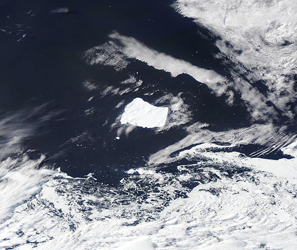
Six months after Iceberg A23a became trapped over a column of whirling water, it continues to spin north of South Orkney Island. The Moderate Resolution Imaging Spectroradiometer (MODIS) on NASA’s Aqua satellite capture a true-color image of the unfortunate iceberg on October 16, 2024.
Iceberg A23a calved from the Filchner–Ronne Ice Shelf, which is located on the northwestern side of Antarctica, in a mass-calving event in 1986. While most of the other ‘bergs calved at the same time floated away, the massive A23a grounded in the Weddell Sea off the coast of West Antarctica almost immediately. It was stuck in that location for fourteen years until it began to float freely in 2020. By March 2023, A23a was riding the currents on a typical path, apparently heading towards the Southern Ocean via “iceberg alley”, where it would eventually melt.
Iceberg Alley is the term used for a part of the Circumpolar Current that heads north of South Orkney Island. This strong current frequently captures icebergs, which float along until they reach relatively warm waters and begin to melt. However, the sea floor under the Current affects the flowing water above it. In particular, a small seafloor lump called the Pirie Bank interacts with the flowing current to cause it to spin. This can create a column of rotating water from near the seafloor all the way up to the surface.
Known as a Taylor Column, the spinning water can be quite long-lived and things captured in the column may stay there for days, or months, or more. According to an August 2024 story published by the BBC, a scientific buoy placed in a different Taylor Column near the Pirie Band was trapped for at least four years.
A23a’s spin-cycle over the Pirie Bank was first noticed in April 2024. It still continues to rotate about 15 degrees a day in nearly the same location. How long this will continue is anyone’s guess.
Image Facts
Satellite:
Aqua
Date Acquired: 10/16/2024
Resolutions:
1km (160.6 KB), 500m (351.9 KB), 250m (939 KB)
Bands Used: 1,4,3
Image Credit:
MODIS Land Rapid Response Team, NASA GSFC
